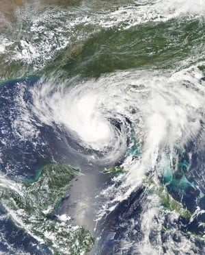
Hurricane Isaac is strengthening and on its way to New Orleans.
Hurricane Isaac is heading right for the Louisiana coast now that it has reached Category 1 hurricane status on the Saffir-Simpson scale. The tropical storm turned into a hurricane late Tuesday morning according to the National Hurricane Center, with maximum sustained speeds of 75 mph pushing it into hurricane status.
At 350 miles-wide and moving at the speed of 10 mph, according to the LA Times, Hurricane Isaac is monstrous and slow-moving. The National Weather Service’s Storm Prediction Center has issued a tornado watch for southeastern Louisiana and coastal Mississippi eastward to the Florida Panhandle. But New Orleans is expecting to get hit the hardest.
Even though New Orleans Mayor Mitch Landrieu said, “We fully expect that we will get the brunt of it” at a briefing on Tuesday, the city should stand firm against Hurricane Isaac. Preparations for the incoming hurricane include a new levee and pump station system that allows operators to remain on site during an oncoming storm. Levees have also been raised from only four feet tall to 16 feet tall, and some flood walls now stand 30 feet tall. Hopefully such preparation will prove successful when the city, warned to have six to 12 feet storm surges and 20 inch rainfalls, is hit.
President Obama warns not to “tempt fate” with the slowly approaching Hurricane Isaac in a statement made at the White House and urged residents to listen to warnings and evacuate if necessary.
Hurricane Isaac is expected to reach land along the southeastern Louisiana coast by nightfall Tuesday.


